

|
|
This has been the best storm season in Ireland for years and for me personally it has been highly rewarding with several rounds of warm weather in conjunction with sferic-rich daytime storms, an elevated plume night storm and a beautiful rope funnel cloud. I was already satisfied with what I had captured this season and considered anything else to simply be icing on the cake. My photographer friends and I joked about getting lucky enough to get a second plume event, this has never happened in our lives before in N. Ireland yet despite our jokes deep down we all felt that another plume type set-up was possible given the way this season was going.
My Wife Roisin was on holidays and the weather looked uneventful on the first week with cool and overcast skies being the norm however each day the temperature was starting to rise again and with it was the gradual change in the models towards a warmer and more unstable outlook. Conor McDonald, Paul Martin and John Fagan and I chatted in great detail about the charts and pondered if another plume event was possible, even as far as one week away the charts were going crazy and it looked like a short hot spell was on the cards with a risk of storms however none of us were getting excited just yet at this range as the models tend to change closer to target day. We were optimistic yet cautious at the same time forwe didn't want to set ourselves up for a disappointment yet something told us that this set-up was worthy of our attention. I was ready for a big let down on the days ahead, usually what happens is the CAPE vanishes completely and the unstable plumes shifts to the E in the last minute giving England all the storms and leaving Ireland in the cooler unexciting air. Three days later our excitement levels soared for not only was the plume still there it had also been upgraded, it got to the point that it looked like this was actually going to happen, no downgrades ar all, we were getting a major convective set up.
We would get several days of hot weather with a big break down expected on July 19th. GFS and other models all agreed that extreme instability (by Irish standards) would be present across UK and Ireland on what would be the hottest day of the year. Models were showing 26C over Ireland and even 20C at midnight. The humid moisture rich air advecting upwards from the SE was packing over 2000 CAPE with higher resolution models showing near 3000 CAPE in places. The lifted index was a staggering -8!!!!, I have seen storms with LIs of -5 or even -6 before however -8 is something I never even dreamed would happen across Ireland. In fact, google LIs -8 and it will say something similar to ''extremely unstable - violent thunderstorms and tornadoes possible''. 2000 CAPE and LIs of -8 were values that dreams were made from, furthermore the maps were also showing strong speed shear and backing winds indicating that thunderstorms would be organised and severe with a risk of supercells, tornadoes and large hail stones 3cm or more in diameter. I heard other forecasters saying they had never seen parameters like it in 15 years of model watching so in a nut shell this was the event I had been waiting for and by great fortune it would take place on Roisin's holidays and in the company of hot and humid air.
The night before the big day was a fond memory for me as I spent hours studying the charts trying to come up with a plan. My Dad had guests around and because it was such a warm night we all sat outside in the back garden in the gazebo under the glorious hazy clear night in t-shirts. There was music on, everyone was drinking, and even though I'm not much of a drinker myself I had one cold corona to cool me down and relax my racing mind. I recall sharing my building excitement for the chase with the guests as I described the set up and how rare it was and I was pretty sure that my excitement was infectious as everyone seemed to be intrigued. I even used an empty beer bottle to represent a thunderstorm updraught and changed its orientation with respect to the table surface to visually show the effects of wind shear. The night was balmy and beautiful, the gazebo had an array of blue LED lights which looked surreal in the semi darkness and in the sky bright planets Mars and Jupiter shone with pride in the dusky blue Summer night.
As I was pondering all this while going crazy over the charts Conor McDonald rang me and we ended up having a very excited chat about the potential. We discussed the set-up at length examining the pros and cons and possible locations and timing, we even joked about getting hail dents in the van, we laughed because this was actually reality, our minds were highly charged with anxiety and adrenaline, after all, this was the kind of thing that we lived for. That night ESTOFEX and Convective Weather issued warnings with the latter issuing the highest warning for W. Ireland that I had seen in years, furthermore Met Check were taking things to the next level mentioning 4cm hail, flooding, lightning and even a risk to livestock. Conor and I decided it would be late initiation the following day so best to get some sleep then work out the details by late morning.
Target day - I love waking up to warm weather as soon as you step outside in the morning. I enjoyed a good breakfast then Roisin and I filled flasks and made sandwiches, packed bottles of water and had everything ready in case we needed to leave in a hurry. I made sure to put on strong sun cream too as UV levels were extremely high. I had already put £30 of diesel in the van, checked water, oil and tyre pressure levels and gave the van a good wash. All my camera gear was charged, lenses cleaned and drone charged, absolutely everything was ready so all we needed to do was get in the van when things kicked off. It all sounded so easy with these exciting values however it was anything but, where would the target area be?, what if we chose the wrong area and missed everything?, what if nothing happened at all?. at 11am it was already 26C and by early afternoon it was a stiffling 30C below the border making this day a scorcher!!!, I wasn't relishing the long drive in this heat however the high temperature was promising for solar heating this strong would help fire storms later.
I sat outside in the back garden again with laptop and lemon water and monitored everything I could under the blazing sun. I really needed to make the rite decision so I had to call upon all my instincts and forecasting experience to make this day work. The country was bone dry with no precip over land and to the untrained eye this would be concerning however the fact that nothing had happened yet by early afternoon meant that things could explode later, this was a classic loaded gun scenario, however what would pull the trigger?. This day had two potential episodes which needed careful watching, the first was the west coast, models were keen to fire cells there this evening from 21.00 onwards, these cells would move N/NE flanking the Sligo and Donegal coastlines then later the N coast/Ocean then finally affecting W. Scotland later in the night. The second event was much later in the night when an elevated plume would move up over the Irish Sea and affect the E portion of Ireland so it would be a case of choosing one event or chasing both. If we went W then we could quite possibly put ourselves out of position for the elevated storms and vice versa, so what would we do?.
GFS showed widespread CIN across the country, in fact, the strongest CIN I have ever seen in a storm event so I was deeply worried that there would be no storms at all. I was almost 100% certain there would be no storms in the centre of the country or any plume there either so I wasn't going to hold out for that nonevent. Furthermore CIN was less along the west coast and this was where I was originally targeting. High CAPE and good shear there with models showing precip all indicated that storms could fire there, in fact, from Mayo through Sligo then Donegal looked to be the best locations. Cold air loft was expected to feed in from the west ahead of a trough which would help erode any cap and a small surface low would also help with lift, this combination of events in conjunction with intense surface heating would be the likely trigger for storms and any storms which did fire could be supercells or at the very least organised multicell lines. Later these storms were expected to grow into an MCS or Mesoscale Convective System and I was confident these would produce night sparks also and that our target area to the W was a good one, in fact, it was begging to be chased. We all chatted on facebook about this and we all agreed that W was best and that Mullaghmore in Co. Sligo would be a great viewing location. By 17.00 radar showed showers breaking out over the sea to the west so it was fair to say the CAP was beginning to erode. All the chatting was done, it was now time to act, the chase was on.
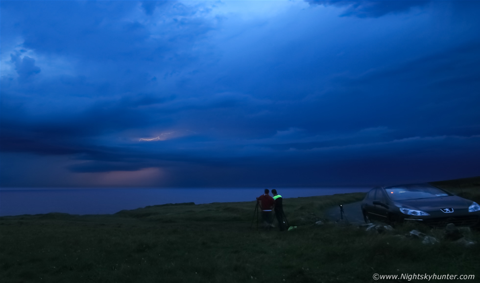
Conor arrived in Cookstown then Roisin and I and Conor drove to Omagh and met up with Paul Martin and Tracy Shakey then we all headed SW in two vehicles into the hot early evening sun. Once we neared Kesh I saw distant towers over the W and NW horizon, I was sure they were storms, we pulled over at the marina and checked radar with Paul and Conor, yip confirmed strong storms on radar with red cores and already producing prolific sferics!!!, this was happening, the CAP had broke and 2000 CAPE was being unleashed in an explosive manner. We needed to get there fast because I felt sure more storms would fire so we drove on at an even faster pace, I could sense the building excitement in the air. We stopped again in Belleek where we met John fagan and now we were a caravan of three vehicles chasing W. While on the main road to Mullgahmore we could see massive solid charcoal grey updraught towers back lit by the sun over the ocean and sheared to the N as they exploded in real time, Roisin and I marveled at their real time evolution, I simply couldn't wait to get there so I drove as fast and safely as I could, then we arrived at Mullaghmore on the W coast and had a terrific view across the Atlantic Ocean. We had witnessed terrific storms from this location in the past and I felt certain this beautiful location was going to produce once more.
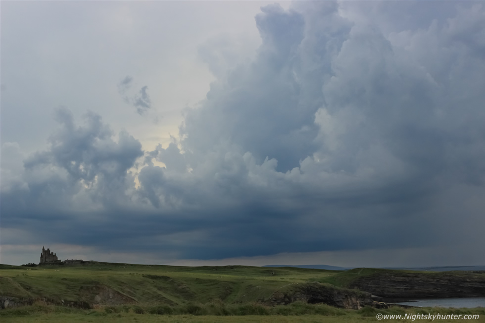 |
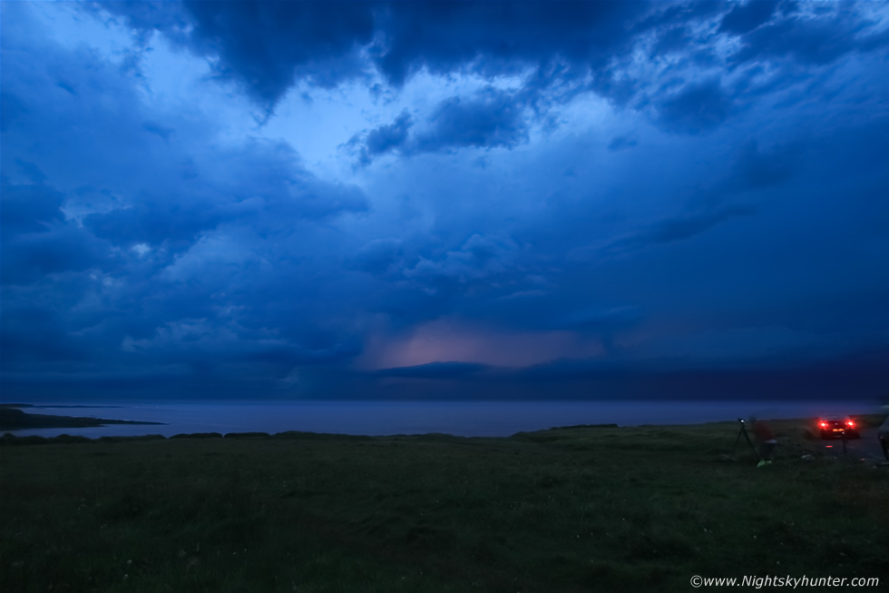
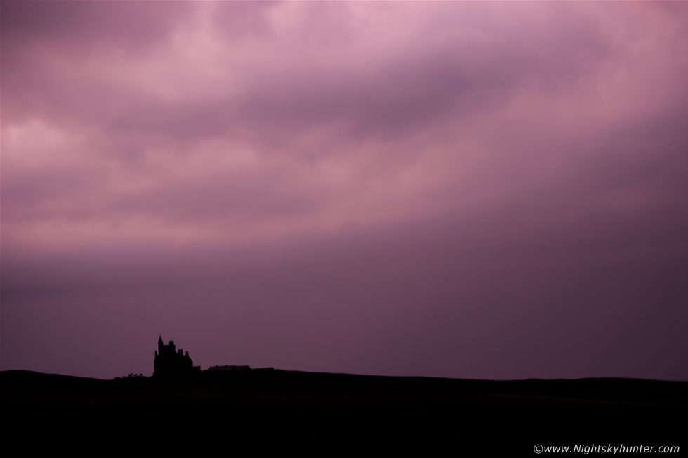
Upon arrival I met photographer Noel Keating who had been watching the situation for the last couple of hours and soon all of us where on location watching developments. There was a constant train of convection crossing the ocean from the S with towers leaning over from the shear however it was evident within minutes of our arrival that these cells were elevated which meant that the chances of tornadoes were almost zero and because of their elevated nature and grey cloud and muck which often accompanies convection in a moist warm sector event it meant that cells were not photogenic either. However this didn't concern us one bit, they would be firing in high CAPE and sheared so we would still be in for a chance of elevated supercells or organised lines and perhaps even an MCS. We decided to take in the view and relaxed enjoying the sky visually while we waited for the light to drop, there was still two hours until sunset so we had time to kill and have a brew and chat while carefully monitoring the sky. This was a new storm building in front of us with Classie Bawn castle in the foreground, note the long base with precip vented well forward (to the R) from the strong shear. At first we thought we were hearing the rumble of the sea then we realised it was thunder which was rumbling away almost constantly which really got our attention, this storm must be spewing out unseen bolts high up within the towers.
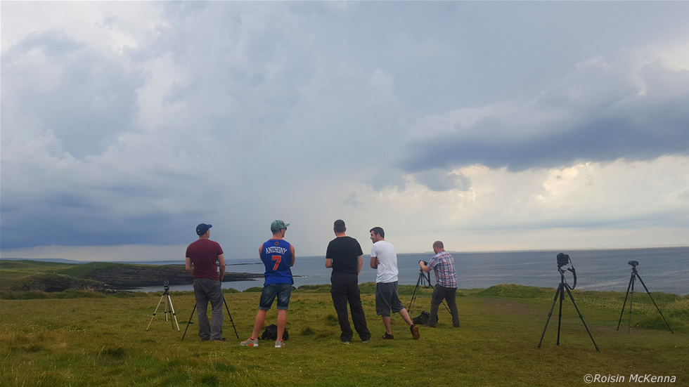 |
Roisin took this nice memory image using her mobile phone. From L to R - Martin McKenna, Conor McDonald, Paul Martin, Noel Keating and John Fagan. As we watched we began to see lightning flicker within the core high above our heads. If this activity could hold out until darkness fell we were going to be in business. We were not getting rained on yet so I took advantage of the weather and launched the Phantom 3 drone for some memory footage of us watching the clouds.
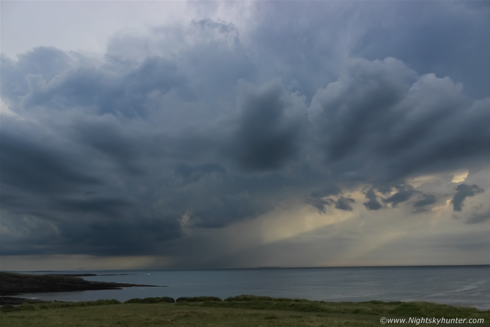 |
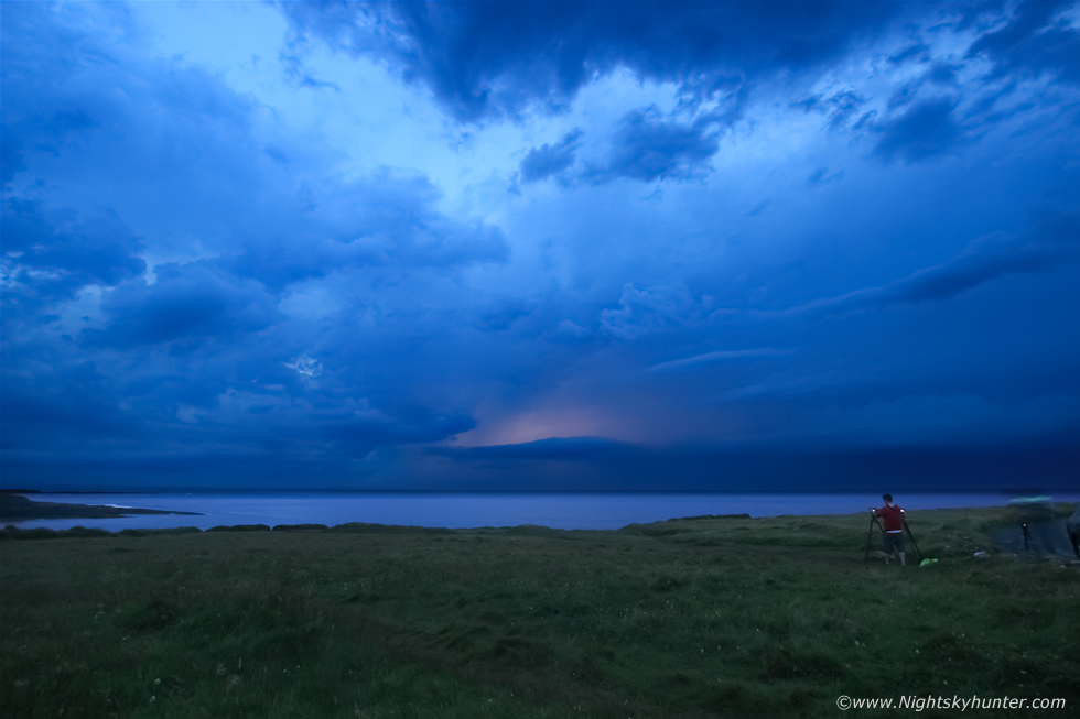
The storm was leaning over well with continuous rumbling far out over the sea while crepuscular rays pierced through the murk, note the back building flanking towers aloft. As the sky grew darker we watched the advance of a big cell heading towards us from the general direction of Sligo, at first we couldn't see it coming due to the haze and murk which masked it's approach however lightning flashes betrayed its presence and soon it came into view with a massive anvil spreading across miles of sky. The cell slowly edged in producing more lightning while a second storm fired over the sea to our right at the same time, a beautiful grey mammatus display was evident under the downwind side of the anvil spreading across the zenith however we didn't get any images as our attention was fixated on the lightning in front of us near the castle. Kenneth McDonagh from Dongeal Weather Channel arrived on the scene so there was now eight of us storm spotting from this cliff top location.
Paul got a radar update and showed us this storm, but what shocked us was what was coming behind it, a massive organised line of very strong cells with red cores where heading straight toward us once this one passed, it looked like we would be getting yet another show and by then the sky would have darkened significantly, however before then we still had this one to enjoy. Precip was blown ahead of the cell and was dropping on us downrange from the anvil aloft, big drops began hitting the camera lenses and bolts flickered close by as the other cell flashed behind us, we were all kneeling down low for safety as the lightning got closer, I was not concerned as all the bolts were in-cloud, no c-gs, so we stuck it out longer than usual until the bolts began lashing overhead then everyone dashed for cover as heavy rain hit. Roisin and I took shelter in the van.
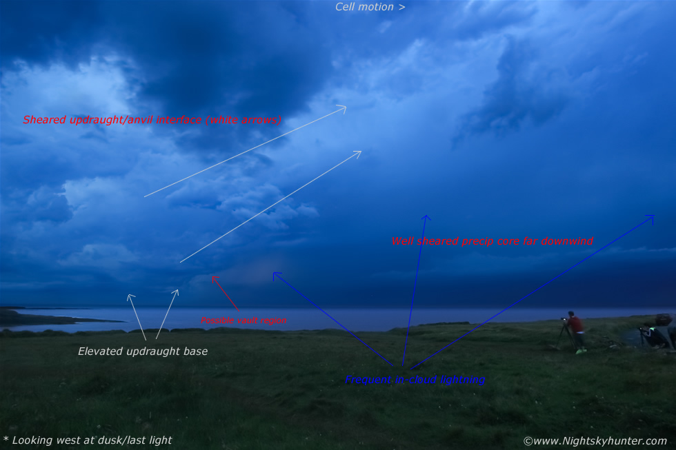 |
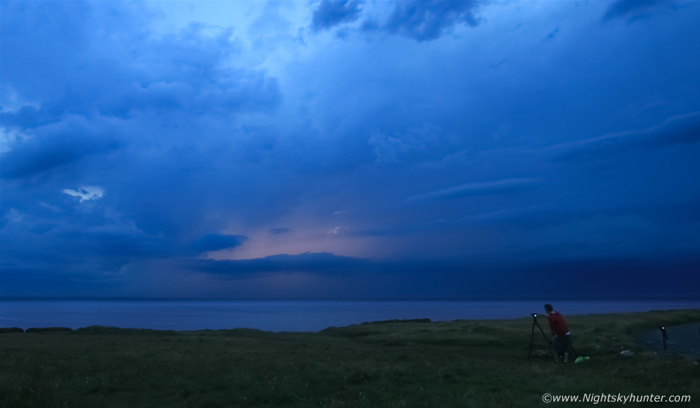
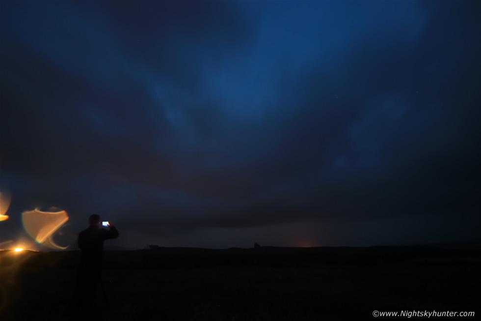
Once the rain stopped everyone got back outside within minutes and it was then that the event of the night began. That big cluster on radar of sheared storms was now evident behind the first storm and it fell straight into the epic category in an instant. It was that atmospheric transition period between twilight and darkness which I love and the local light seemed even darker than usual from the heavy cloud cover, the atmosphere was still and quiet, it was the perfect stage for the perfect light show. This is an annotated image showing what was going on, this linear complex was moving L to R across the ocean from SW to NE and we had the perfect side-on view as the cells moved at a snail's pace over the highly unstable air above the Atlantic. The towers were sharply sheared downwind where they morphed into their anvils dropping precip for miles downrange from their elevated updraught bases. As we observed this massive complex cross our line of sight and into the distance we all watched with joy as three main areas lit up with lightning to the W, NW and N.
 |
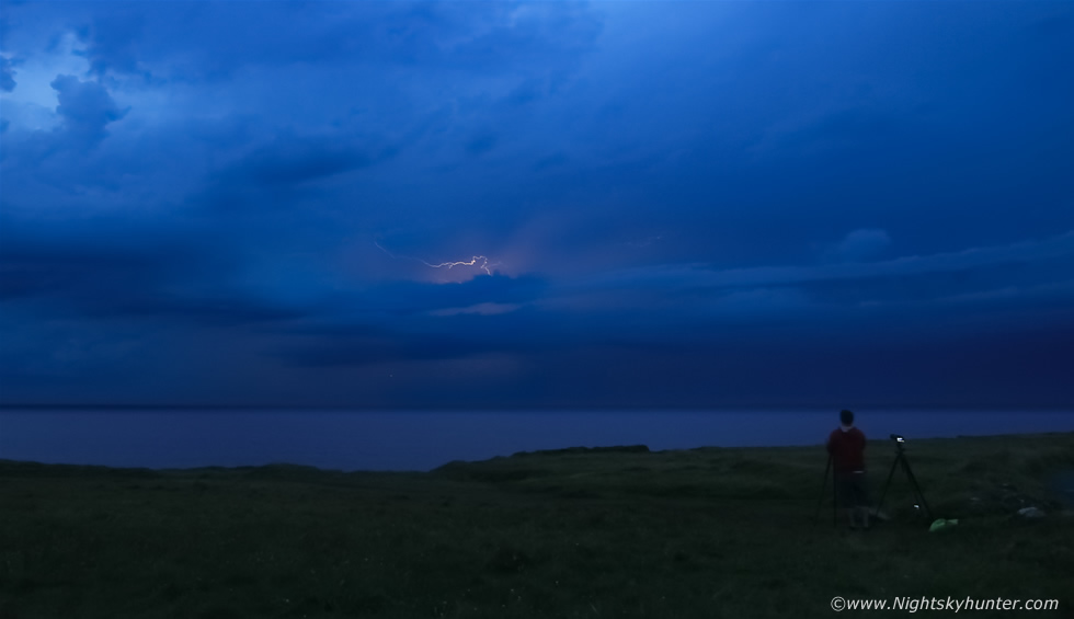
I began taking short exposures at 10mm on continuous shooting with the intention of making a time lapse and Roisin began filming using her mobile phone while the rest of the guys began watching and shooting in the semi darkness, I could sense everyone's concentration and focus. The lightning display which came from this storm was like flashing lights on a Christmas tree with pink flashes lighting up the storms every couple of seconds. These storms would later produce 45,000 lightning strikes in total before the night was over, amazingly there were very few c-gs, in fact, all the lightning I observed with in-cloud with crawlers, all the lightning was embedded deep inside the cells updraught/anvil/precip interface and appeared as pink pulsations or flashes from inside, the above image shows one of these internal flashes caught in the act. Photography was extremely difficult for this reason so I didn't score well in the image department so these are really memory scenes to document the moment. To tell you the truth, no matter how good a photographer you are and no matter how good an image you got it still wouldn't even do this scene justice at all, this was without question a visual event and the reason why most of us starred in awe as the warm Summer night turned into an electrified spectacle.
 |
My favourite memory image, pink lightning....flash..flash...flash while the sedate ocean stirred silently in the distance, all of us stood in the group either watching or shooting and ''ahhhing'' and ''wowing'' when a multiple flash event happened, at times we could see long red and pink bolts whipping across the clouds from the inside, from underneath I'm sure these would have looked like spider lightning. Noel Keating can be seen on the R with camera in action.
 |
One of the bolts jutting out from the side of the cell, the electrical activity was prolific and often high up inside the precip core. Flash...two sec's...flash....two sec's...flash flash flash...flash, this went on for a very long time, this was the most frequent lightning I had ever witnessed and was not dissimilar to some lightning displays from the USA.
 |
The sferic rates from these storms were incredible and by Irish standards really at the top of the scale, this was what we had drove long miles to see, I felt a sense of extreme satisfaction and contentment and great validation for our chose of location was perfect, you cant beat watching storms for hours from the very same spot and not having to move at all.
 |
Noel Keating on the L and Kenneth McDonagh from Donegal Weather Channel on the R. We watched as pink flashes and bolts lit up the clouds in three sectors across 180 degrees of sky. As the storms moved further away from us to the N the activity had increased yet again with lightning flashing so rapidly there was barely a moment when we were not seeing flashes, in fact, Paul Martin even joked that he was getting bored looking at lightning lol, in truth, we were getting spoiled, these were the kind of storms we dreamed about seeing and now it was happening for real rite in front of us. There were currently two organised clusters, we were now seeing them both as they headed away across the W of Donegal, NW and eventually across the N. Atlantic, both systems peaked to the W of Scotland were it was suggested that they were possible elevated supercells before evolving into a full blown MCS. While all this was happening my Wife Roisin done me proud by obtaining 6 min's of great footage taken with her samsung galaxy smart phone which can be viewed on the video below.
 |
Another cell became electrified, it also had a land track and seemed to be heading straight in our direction. It was now full darkness and as the lightning strobed the sky lit up pink once more, one such brilliant flash revealed the ghostly form of Classie Bawn castle in the distance, the scene reminded me of a Hammer Horror Dracula movie.
 |
This was the scene when there was no lightning, complete darkness except for the glow of camera LCD screens, I didn't even know who was beside me. The lightning was getting close and big drops of rain were falling trying to spoil the show, I kept wiping clean my lens every couple of exposures and kept shooting at 10mm.
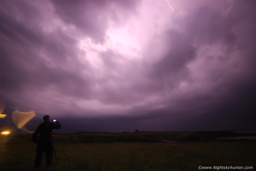 |
Then magic!, huge in-cloud bolt illuminated the clouds from within, the night was turned into brilliant pink, this was my best image from the night, Paul Martin can be seen on the L and Classie Bawn castle on the horizon, you can also make out the bolt which was almost overhead. After this storm passed it seemed there would be nothing else coming up on radar plus the plume now moving up across Ireland over the S and E was a non event, the sferics had stopped once over the midlands so it was simply a mess of rain, this further vindicated that our forecasting and instincts were sharp, W was best and we had witnessed the best storms of the night. We drove home happy but exhausted and it wasn't until 02.00 before Roisin and I where back in the house and earned a proper late night brew.
Video of the chase including drone footage, DSLR time lapse and DSLR video, however the highlight is Roisin's mobile footage which can be seen 3 min's and 15 sec's in which really captures the moment well. The Summer of 2016 has delivered yet again and for the first time in my life I have witnessed two plume type set-ups producing two night lightning displays all within the same season. Thanks very much for reading.
Martin McKenna